|
The Rights of Wetlands InitiativeBy Bill Morgante
Through Society of Wetland Scientists (SWS) meetings and the SWS Climate Change and Wetlands Initiative, a group, including wetland scientists, a climate scientist and attorneys, has developed the proposed Universal Declaration of the Rights of Wetlands and has formed the Rights of Wetlands Initiative. This is a call for wetlands to be given legal rights, similar to how humans have rights. This initiative builds on many Indigenous peoples' knowledge that recognizes nature as a living entity. The group hopes that universal recognition of the Rights of Wetlands will help reduce the destruction of wetlands. The initiative offers an opportunity for improved cross-cultural understanding, respect, and collaboration between Indigenous peoples and other communities. The founding group view the Declaration as an opportunity to promote a paradigm shift and step-change in the human-wetlands relationship that could lead to a fundamental change in the trajectory for global wetland ecosystems. The full text of the Declaration.

Sign the Declaration | Rights of
Wetland Homepage Date: 10/14/2025 Category: News
|
SAV Recovery in the Susquehanna Flatsby Audrey Smylie
The Susquehanna River Flats, located at the mouth of the Chesapeake
Bay’s largest tributary near Havre de Grace, Maryland, is home to the bay’s
largest submerged aquatic vegetation (SAV) bed. Approaching 11,000 acres in
20231, this dense underwater habitat plays a pivotal role in
supporting the health of the bay's tidal wetlands. SAV filters harmful
nutrients and sediments from upstream sources and indirectly supports the
resilience and productivity of wetlands across the Chesapeake Bay, which depend
on clean water and stable shorelines to thrive. Although SAV populations in the
Susquehanna Flats have been vulnerable over the past few decades, the overall
resilience of this ecosystem is significant. 
The recovery of SAV populations in the Susquehanna Flats after tropical storms such as Agnes (1972) and Lee (2011) is a testament to a combination of natural resilience and targeted interventions. Following these storms, which unleashed record-breaking sediment and nutrient flows that smothered grasses, scientists and conservationists implemented several key strategies to aid recovery. Efforts included monitoring water quality, reducing upstream nutrient and sediment loads through improved agricultural practices, and restoring buffers to prevent erosion2.
Additionally, seeding programs and transplanting SAV species were employed to kick-start regrowth in affected areas3. Beyond these direct interventions, the natural characteristics of the Susquehanna Flats have also contributed to the recovery. The Flats' shallow waters and strong tidal currents help flush excess sediments, allowing sunlight to penetrate and promote SAV growth. Recent research has also shown that submerged aquatic vegetation in the Susquehanna Flats plays a critical role in buffering pH levels in the Chesapeake Bay4. During the summer months, dense SAV beds facilitate high rates of photosynthesis, which not only increase oxygen levels but also elevates pH and carbonate mineral saturation states, promoting the formation of calcium carbonate (CaCO3) on plant surfaces. These carbonate particles are then transported downstream into deeper, oxygen-depleted waters, where their dissolution counteracts acidification caused by carbon dioxide (CO2) emissions and aerobic respiration. This natural pH-buffering mechanism highlights another essential function of SAV in sustaining the bays overall water quality and supporting a productive shellfish industry. Recovery efforts in the Susquehanna Flats not only reinforces the ecological importance of SAV but also highlights its resilience. Healthier SAV beds now serve as natural filters, reducing sediment and nutrient loads and creating favorable conditions for tidal wetlands to thrive in the Chesapeake Bay. Tidal wetlands in the Chesapeake Bay are vital for biodiversity, acting as nurseries for aquatic species, providing habitat for birds, and serving as natural flood controls. As scientists continue to study the Flats’ resilience, their findings offer valuable insights into protecting and restoring SAV and wetlands throughout the bay. 
Footnotes: 1. Underwater grasses in the Chesapeake Bay continue upward climb, Chesapeake Bay Program. 2. Susquehanna Flats (CB1TF2), Chesapeake Bay Program. 3. Scientists study mysterious invader in the Chesapeake Bay’s largest underwater grass bed, The Baltimore Sun. 4. Chesapeake Bay acidification buffered by spatially decoupled carbonate mineral cycling, Nature Geoscience. Date: 2/11/2025 Category: News
|
Exploring the Connection Between Coastal Wetlands, Carbon Storage, and Climate ChangeBy Audrey Smylie Coastal wetlands, including marshes, swamps, and SAV beds are known as carbon sinks with the ability to store significantly more carbon than they release. The storing of carbon in these ecosystems, carbon sequestration, reduces the level of greenhouse gasses in the atmosphere. While climate change is threatening the health of our natural environment, preservation of coastal wetlands is critical in mitigating its negative effects.
Carbon dioxide is one of the primary greenhouse gasses causing a global rise in temperature. Wetlands are home to a variety of plant species that capture large amounts of carbon dioxide from the air and store it over long periods of time. According to NOAA, coastal wetland ecosystems capture and store carbon at ten times the rate of a mature tropical forest.1 The process of carbon fixation, plants capturing carbon dioxide and storing it in plant biomass as carbon, is necessary for their growth. When plants begin to decompose, some of the stored carbon is released into the soil where microbes break it down and release it back into the atmosphere. However, the decomposition of plant material occurs at a much slower rate without adequate oxygen levels present. The soils in coastal wetlands are mostly characterized as anaerobic, meaning they lack oxygen. These conditions make these wetland ecosystems favorable for carbon to remain in plant materials rather than being returned to the atmosphere. One study found that coastal wetlands have held approximately 2.9 billion metric tons of total carbon sequestered in their soils.2 ten times the rate of a mature tropical forest.1 The process of carbon fixation, plants capturing carbon dioxide and storing it in plant biomass as carbon, is necessary for their growth. When plants begin to decompose, some of the stored carbon is released into the soil where microbes break it down and release it back into the atmosphere. However, the decomposition of plant material occurs at a much slower rate without adequate oxygen levels present. The soils in coastal wetlands are mostly characterized as anaerobic, meaning they lack oxygen. These conditions make these wetland ecosystems favorable for carbon to remain in plant materials rather than being returned to the atmosphere. One study found that coastal wetlands have held approximately 2.9 billion metric tons of total carbon sequestered in their soils.2
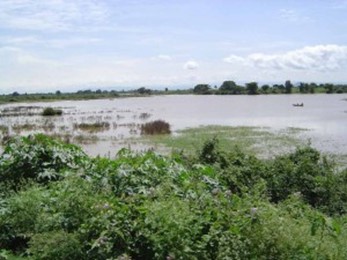
Since coastal wetlands are such an effective carbon sink, the loss of these ecosystems from destruction and sea level rise poses a great risk. The same study cited above revealed an estimated 3.5 million tons of carbon dioxide is emitted annually from the destruction of coastal wetlands.2 Global efforts to protect and restore coastal wetlands continue to be focused on identifying the most productive ecosystems, assessing threats, and centering climate strategies around the survival of these ecosystems. One restoration strategy places “thin layer” sediment to raise land elevation to counter sea level rise and increase plant productivity. This strategy was successfully carried out in 2016 at Blackwater’s National Wildlife Refuge.3 Prior to restoration efforts, this project marsh was transitioning to open water from sea level rise and storm impacts, contributing to an overall decline in the health of Blackwater’s tidal marshes.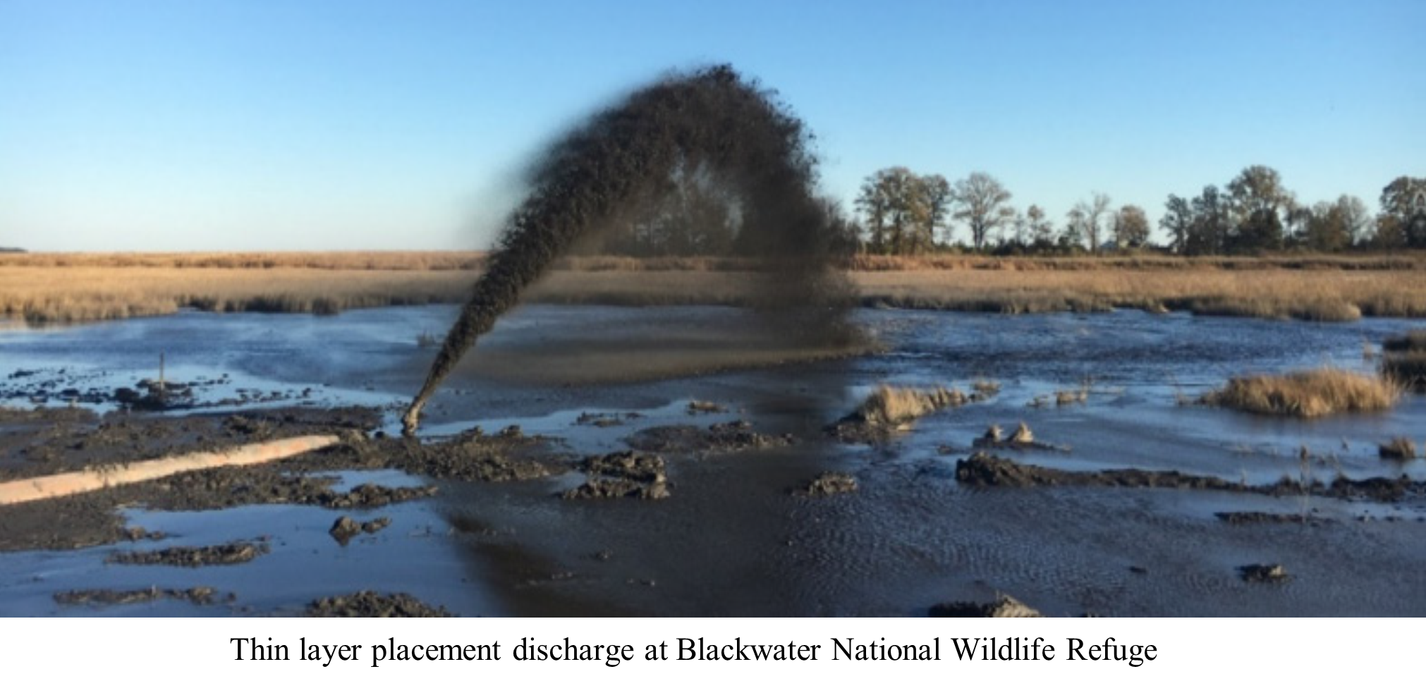
Studies were performed to design a target surface elevation level and identify the amount of sediment required to increase the resiliency of 40 acres of marsh area. Roughly one year after approximately 26,000 cubic yards of dredged sediment material was placed, the target elevation was achieved in 78 percent of the placement area. Higher surface elevations have improved plant resiliency to sea level rise and the overall health of this tidal marsh.
Sediment placement area viewed from Shorters Wharf bridge. October 2016 (pre-project), May 2017 (immediate post-thin-layering), and October 2018 (two growing seasons following thin-layer addition).
_______________ Footnotes: 3. Whitbeck, M., A. McCullough, E. Meyers, and D. Curson, Shorters Wharf Tidal Marsh Resilience Project: Implementation Report, 2019, The Conservation Fund (Arlington, Virginia).
Date: 1/11/2024 Category: News
|
Ditching Maryland’s Eastern ShoreBy Audrey Smylie
Maryland’s coastal areas historically consist of low land elevation and saturated soils surrounded by waterways, often salt marsh. With 48% of land in the Delmarva peninsula in agriculture1, land conditions that are wet make it difficult to make a living in agriculture. An early system of draining ditches helped create more favorable farming conditions yet changed the landscape of the Eastern Shore.
Ditching on Maryland’s Eastern Shore can be traced back to the 1700’s. During this period, farmers and
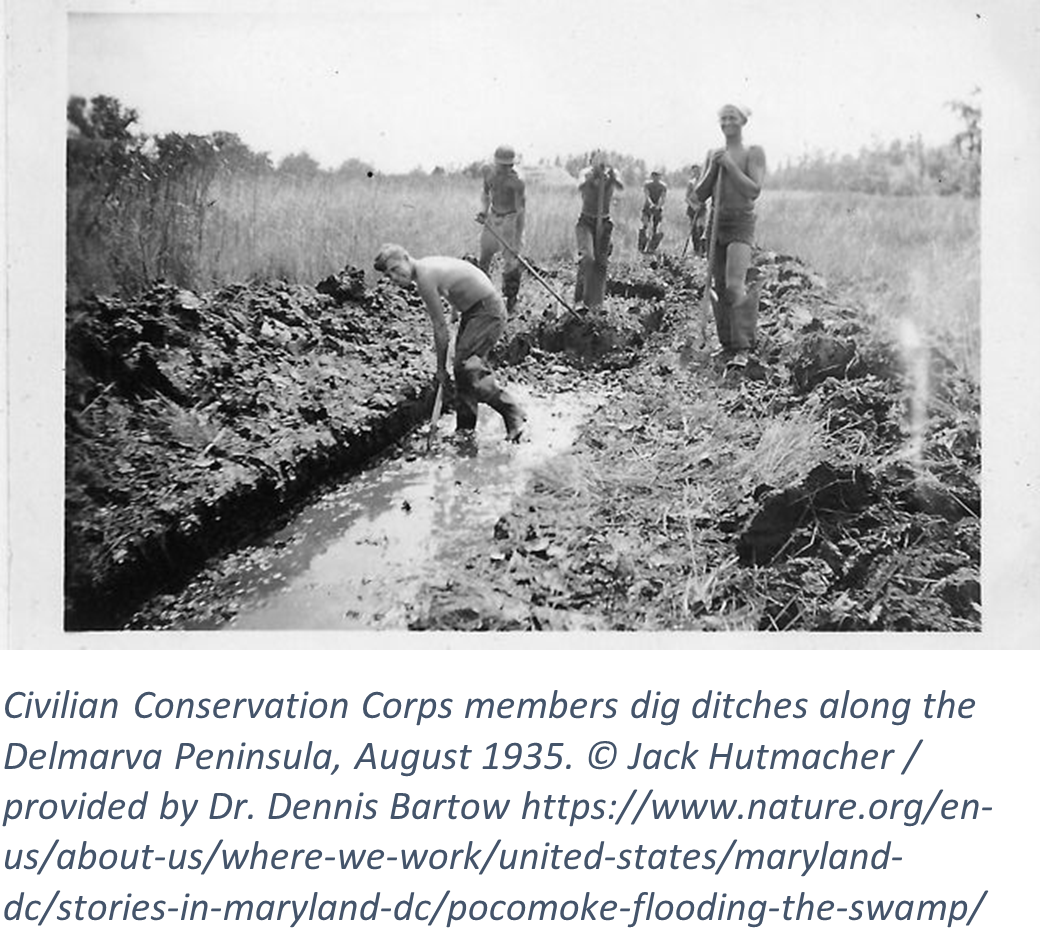 slaves dug ditches by hand to drain land for crop production. The first recorded ditching project in 1789 drained Long Marsh in Queen Anne’s and Caroline Counties. The Long Marsh ditch drained almost 50,000 acres of land and served as a dividing line between the two counties. Ditching evolved during the 1930’s Depression Era when Franklin D. Roosevelt established the Civilian Conservation Corps (CCC) to help reduce unemployment rates2 . On Maryland’s Eastern Shore, the CCC employed young men enlisted to improve land for farming and control mosquitos by ditching thousands of miles of salt marsh. This Federal program was established to employ men, assist landowners, and began a practice best known as tax ditching. With gradual budget cuts to the CCCs after the Depression, tax ditching ended on the Eastern Shore in the 1990’s. At that time approximately 821 miles of tax ditched3 land and hundreds of miles of agricultural ditched land could be found on the Eastern Shore. slaves dug ditches by hand to drain land for crop production. The first recorded ditching project in 1789 drained Long Marsh in Queen Anne’s and Caroline Counties. The Long Marsh ditch drained almost 50,000 acres of land and served as a dividing line between the two counties. Ditching evolved during the 1930’s Depression Era when Franklin D. Roosevelt established the Civilian Conservation Corps (CCC) to help reduce unemployment rates2 . On Maryland’s Eastern Shore, the CCC employed young men enlisted to improve land for farming and control mosquitos by ditching thousands of miles of salt marsh. This Federal program was established to employ men, assist landowners, and began a practice best known as tax ditching. With gradual budget cuts to the CCCs after the Depression, tax ditching ended on the Eastern Shore in the 1990’s. At that time approximately 821 miles of tax ditched3 land and hundreds of miles of agricultural ditched land could be found on the Eastern Shore.
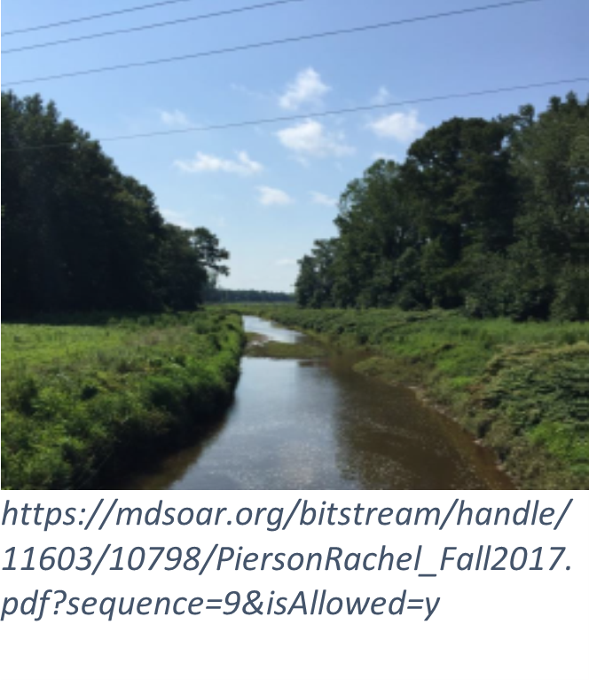
Ditching is no longer a practice on the Eastern Shore; efforts have shifted to focusing on their impacts and how to maintain them. Farmers benefitted from ditches by controlling water flow, capturing nutrients, and reducing erosion. Yet ditching has negative impacts including transporting nitrogen and phosphorous into Chesapeake Bay waterways, reducing marsh vegetation, and degrading wildlife habitat. Today, the Maryland Department of Agriculture oversees multiple organizations implementing Best Management Practices (BMPs) in areas that have been heavily ditched. One practice involves planting vegetation on the banks of ditches to reduce erosion and filter pollution from nearby farmland. Another common restoration practice is installing ditch plugs to block drainage restoring hydrology to wetlands and improving water quality. Though the overall impact of ditching has been debated, their impact on the landscape of Maryland’s Eastern Shore is undeniable.
Footnotes:
Date: 6/30/2023 Category: News
|
Happy World Wetlands Day - February 2, 2023!
Sackett v. EPA
A 15 Year Wetlands Legal Battle with an Expected Decision in 2023
By Audrey Smylie
The Clean Water Act (CWA) provides a basic framework for preventing, reducing, and eliminating pollution into Waters of the United States (WUS). Note that WUS includes wetlands. Under the CWA, the Army Corps of Engineers, and Environmental Protection Agency (EPA) oversee a permit process that regulates the placement of dredge or fill material into WUS. The supreme court case of Sackett v. EPA poses the question: What is the proper test for determining whether wetlands are considered “Waters of the United States” under the CWA? The outcome could determine how the EPA decides which aquatic environments are subject to regulation under the CWA in the future.
In 2004 Chantell and Mike Sackett purchased a residential lot near Priest Lake, Idaho with plans to build a home. Shortly after they began filling the wetland with gravel, the EPA alleged the property violated the CWA and demanded they immediately stop construction and remove the fill. Instead of adhering to the EPA’s request, the Sackets sued in 2008 arguing that the CWA does not apply to their property thus they should not have to comply with the order. A fifteen-year legal battle ensued and resulted in the 9th Circuit Court upholding the decision that the EPA can regulate wetlands on the Sackett’s property under the CWA. Following this ruling, the Sackett’s appealed arguing the “significant nexus” test used (to determine if an area is wetlands) is not the proper test for determining whether wetlands are protected under the CWA. The appeal made it to the Supreme Court where it is being decided whether the Ninth Circuit set forth the proper test for determining whether wetlands are 'Waters of the United States' under the CWA.
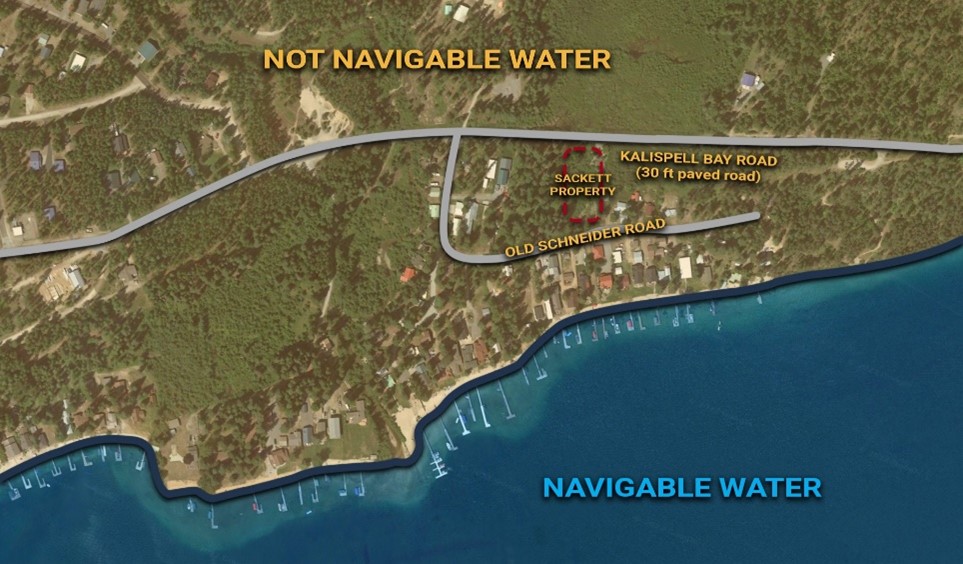 Photo courtesy of reason.com
In October 2022, the Supreme Court began hearing arguments for Sacket v. EPA. The Sackett’s legal team and stakeholders argued the significant nexus test should be abandoned because it is too broad. Since the CWA only authorizes the EPA to regulate wetlands that have a continuous surface connection with a body of water protected under the act, the significant nexus test goes beyond the scope of the CWA. The Sackett’s encouraged the court to adapt a test that requires the wetland to have a continuous surface connection with a protected waterbody and does not extend beyond the authority of the Congress’s Commerce Clause . The EPA countered the Sacketts argument stating the CWA does not require a continuous surface connection in its text and to do so would drastically limit the CWA’s ability to protect our nations waters. Applying the significant nexus test, which considers wetlands to be protected by the CWA if they individually or cumulatively significantly affect the integrity of other protected waters, is consistent with the statute’s language and intent. While historically the CWA focused on navigable waters, the EPA recognizes wetlands adjacent to navigable waters must also be regulated to protect those waters.
A decision in the Supreme Court case of Sackett v. EPA is expected in June of 2023. A win for the Sackett’s would result in the EPA and Army Corps of Engineers fighting an uphill battle regulating wetlands beyond those with a continuous surface connection to protected waters. Should the court’s decision uphold the EPA’s regulation authority, wetland protection at the federal level will be clarified and strengthened.
1 The Commerce Clause refers to Article 1, Section 8, Clause 3 of the U.S. Constitution, which gives Congress the power “to regulate commerce with foreign nations, and among the several states, and with the Indian tribes."
Date: 2/2/2023 Category: News
|
Wetland Management in Cameroon
by Audrey Smylie
The Illinois Natural History Survey, the University of Illinois-Urbana Champaign, the University of Bamenda, Cameroon and others collaborated to present a seminar on wetlands management in Cameroon attended by Wetlands Associate Audrey Smylie. The seminar presenter, Kongnso W. Edith, is a PhD fellow at the University of Bamenda, Cameroon and a researcher at the Ministry of Scientific Research and Innovation in Cameroon. Cameroon is located on the Gulf of Guinea at the intersection of western and central Africa. With a population of 25.5 million and over 475,442 square kilometers of land, it is comparable to the size of Texas. Wetlands in Cameroon, once referred to as “wasteland,” and were typically owned by the government and used by local people for cultivation or dumping. Once the Cameroon government recognized the social, economic, and environmental importance of wetlands, they began to look at management approaches and became a contracting party of the RAMSAR Convention (see
2/2/15 BPW blog on RAMSAR), which provides guidance on the use and conservation of wetlands. Contracting parties of the convention are committed to: - Working towards the wise use of all wetlands
- Designating suitable wetlands for the list of Wetlands of International Importance (the “Ramsar List”) and ensuring their effective management. (The Ramsar List includes the Chesapeake Bay)
- Cooperating internationally on transboundary wetlands, shared wetland systems, and shared species
Cameroon’s seven RAMSAR sites comprise a total surface area of 827,060 hectares. Although they have been able to identify priority sites, Cameroon continues to face challenges in wetlands management, including: - Significant pressure to inappropriately exploit wetlands for economic gain resulting in wetland destruction or degradation
- The absence of decision-making processes for regulation of wetland activity (plans of action and implementation)
- Insufficient research
- Invasive aquatic plants
- Lack of agreement between stakeholders on regulatory approaches
- Upland waste disposal sites
A case study of urban wetlands in the Yaoundé Sub-Division found 32% of the area covered by settlement (over 5,000 houses). Wetland health in Yaoundé is jeopardized by farmers’ heavy pesticide use, waste disposal, and dumping.
Cameroon continues to explore solutions to their various problems in wetlands management. Focus points for the Central Government’s future of wetland management in Cameroon include: - Stakeholder involvement from start to finish to ensure a participatory approach to management
- Applicable laws and a strong institutional framework to ensure sustainable management
- Use of remote-sensing and GIS as a time- and cost-effective management and monitoring strategy
- The creation of wetland buffer zones to keep urbanization in check
- Funding wetland research

Municipal Lake, Yaoundé
Lagdo, Far North Region
Date: 9/21/2022 Category: News
|
Annapolis' Living Wave Wallby Audrey Smylie & Bill Morgante
Have you heard of a living wave wall? Many Maryland marinas incorporate wave attenuation structures or wave walls to reduce wave action since storm waves and boat wakes can harm boats and marina structures. Wave walls are typically made of nonliving materials, yet a wave wall with live oysters can be found in Annapolis! The Board of Public Works’ Wetlands Administration Associate and Wetlands Administrator recently visited Annapolis’ Eastport Yacht Club (EYC) to learn firsthand about their living wave wall.
Concrete "wave wall" shelves.
Located at the busy confluence of Spa Creek and the Severn River, EYC docks receive sizable swells from storms and boat traffic. Swells are a series of waves formed by wind blowing over a large area. With the help of dedicated volunteers and the Chesapeake Bay Foundation’s Oyster Restoration Center, the EYC designed a living wave wall to buffer swell and boat traffic. Under EYC docks, the wave wall is made up of concrete shelves (like a bookcase) that receive concrete triangles containing juvenile oysters called spat. In November 2011, EYC received a wetlands license from the Board of Public Works to authorize installation of their living wave wall. Once installed, the wall’s oyster triangles are inspected and replenished annually. Since oysters filter around 50 gallons of water per day, over the past 10 years water quality around EYC has benefited from wave wall oysters.
The annual maintenance of inspecting and adding oyster spat to the living wave wall at EYC commences each fall. EYC volunteers create triangular slabs using a special concrete recipe that provides the best conditions for oyster growth. Each slab is sent to the Chesapeake Bay Foundation Oyster Restoration Center to be impregnated with spat and then transported back to EYC. Next, volunteer divers suit up and first check the condition of the concrete triangles on each shelf. Oysters are measured, some aged oysters are removed, and some new triangles are installed. This effort is necessary to maintain the wall’s function, which mimics a three-dimensional oyster reef. For the installation of new triangles, paddle boards are used for transport to the divers.
Concrete triangle covered in juvenile oysters.
All in all, the annual maintenance of this living wave wall is a vigorous process, especially for the divers! We noted that EYC volunteers and divers alike share a love of water and environmental stewardship. To learn more about the living wave wall and to check out some underwater footage, visit https://www.eastportyc.org/oysters. For other BPW Wetlands Web Blog posts on oysters, see blog posts from 8/15/18 and 5/17/17.
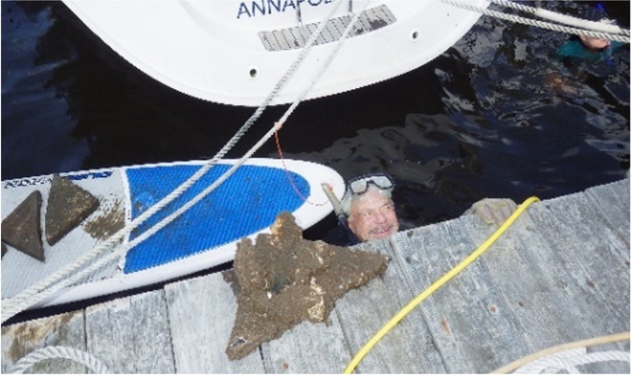 EYC volunteer diver with concrete triangles on a paddleboard. EYC volunteer diver with concrete triangles on a paddleboard.
Date: 12/29/2021 Category: News
|
"Assumption" Provides an Opportunity for Maryland to Manage Waters and Nontidal Wetland Resourcesby Bill Morgante. Gary Setzer, MDE Senior Advisor, contributed to this post
One way to expedite the licensing of nontidal wetlands projects in our State would be for Maryland to “assume” the administration of the federal Section 404 Clean Water Act1 program.
This topic – whether and how individual states can assume administration of Section 404 of the Clean Water Act from the federal government – was on the agenda at the recent Association of State Wetland Managers Annual Coordination Meeting in Leesburg, VA. This gathering included 119 wetland managers whose mission is to protect wetlands in the 35 states (plus D.C.) they represent.
Through Section 404 of the Clean Water Act, the federal government regulates discharge of dredged or fill material into waters of the United States, including wetlands. Part of that law allows states, in certain circumstances and with approval from the Environmental Protection Agency, to step into the federal role and administer the 404 program in navigable waters.
Currently, New Jersey and Michigan are the only states authorized to assume Section 404 authority; Maryland and other states are presently evaluating the costs and benefits of assumption.
The Federal Section 404 Program
Section 404 regulated activities include fill for development and infrastructure expansion including roadways 2. Some farm activities are exempt.
Implementing Section 404 is assigned to the U.S. Army Corps of Engineers (Corps) which must issue a permit before a project may discharge dredged or fill material into regulated waters and wetlands. Discharge of dredged or fill material will not be permitted if: (1) a practicable alternative exists that is less damaging to the aquatic environment; or (2) wetlands and waters would be significantly degraded.
Water Quality Certification is a prerequisite to a federal Section 404 permit. Under the 404 Program3, a state must certify that activities discharging dredged or fill materials into state waters will not violate the state's water quality standards adopted to protect aquatic life, drinking water, and recreation.
An applicant for a permit must demonstrate steps taken to avoid impacts to wetlands and to minimize impacts that cannot be avoided. For unavoidable impacts, the permittee may have to provide compensation.
The magnitude of the proposed impacts determines the extent of the Corps’ review:
- Minimally adverse impacts usually require a General Permit. This permit process is less onerous for the applicant than an Individual Permit review (see below) and allows certain activities to proceed with little or no delay. Example: minor road activities and utility line backfilling.
- Potentially significant impacts require an Individual Permit. The Corps evaluates these applications under a public interest review, as well as the environmental criteria set forth in the Section 404(b)(1) Guidelines.
Maryland and AssumptionThe preamble to the Maryland Nontidal Wetlands Protection Act states: “That it is the State’s intention to evaluate the feasibility of assuming the permit program under Section 404 of the Clean Water Act after implementation of a statewide permit program for nontidal wetlands4.” The Act was adopted in 1989 and Maryland’s Statewide nontidal wetlands program began in January 1991.
State officials met with EPA officials in 1993 to review Maryland’s statutes and regulations and assess their consistency with the Clean Water Act. Differences identified at that time demonstrated that the General Assembly would have to make law changes before Maryland could assume Section 404 authority. Legislation to align Maryland’s statutes with the Clean Water Act as a prelude to developing a State application for assumption, however, failed in the 1994 and 1995 General Assembly sessions5.
Nearly 25 years later, Maryland is again investigating the benefits and costs associated with assuming the Section 404 program. The Initial Report of Governor Hogan’s Regulatory Reform Commission (2015) recommended: “The State should pursue transfer of jurisdiction from the Army Corps of Engineers to the Maryland Department of the Environment. This will eliminate a huge time delay and will remove a possible third level of review for permits and applications.” The MDE has reopened its dialogue with EPA to determine the statutory changes that will be necessary to align Maryland’s nontidal wetlands and waterways statutes with Section 404 of the Clean Water Act.
NOTE: The Clean Water Act requires the federal government to retain permitting jurisdiction over “all waters which are subject to the ebb and flow of the tide shoreward to their mean high water mark . . . including wetlands adjacent thereto6.” As a result, it is unlikely that the Board of Public Works issuance of State tidal wetlands license would be affected if Maryland assumed the 404 Program since it is targeted toward nontidal wetlands.
1 33 USC § 1344
5 1994 General Assembly: House Bill 414/Senate Bill 291 offered amendments to Title 8 of the Natural Resources Article, Subtitles 8 and 12, identified by EPA as necessary for the State to assume Section 404 authority.
1995 General Assembly: House Bill 820/Senate Bill 649 offered amendments to Title 8 of the Natural Resources Article, Subtitles 8 and 12, to improve consistency between the State and federal nontidal wetlands programs.
6 33 USC § 1344(g)(1)
Date: 7/11/2019 Category: News
|
Study of Living Shoreline Projects Licensed by the MD Board of Public Works between 2013 & 2018More than ten years ago, State Tidal Wetlands Law was amended by the Living Shoreline Protection Act of 20081 to mandate that “improvements to a person’s property against erosion shall consist of Living Shorelines2 unless an exception is granted authorizing structural measures3.” The preference for using a Living Shoreline approach to stabilize shorelines against erosion derived from growing concerns that climate change is connected to sea level rise leading to increased shoreline erosion, and that shoreline protection using Living Shorelines is optimal because they “trap sediment, filter pollution, and provide important aquatic and terrestrial habitat4.”
In the decade that followed, the Board of Public Works has issued State Tidal Wetlands licenses for numerous Living Shoreline projects in Maryland’s tidal waters5. Based on this body of experience of BPW-licensed Living Shoreline projects, now is an appropriate time to evaluate the success of the Living Shoreline approach.
Specifically, Wetlands Administration evaluated 16 Living Shoreline projects that were licensed in the past five years to:
- Evaluate success for these 16 living shoreline projects.
- Inform the Board of Public Works about whether the intent of the 2008 amendment has been fulfilled.
- Encourage the creation of a Living Shoreline database in Maryland usable by living shoreline designers, property owners with living shorelines, and property owners considering this approach.
Success of Living Shoreline Projects Summary
Of 16 Living Shoreline projects evaluated, 15 are successful. This study focused on three specific criteria assessed based on site visits to each site without detailed scientific study.
The three criteria include the project’s ability to: stem erosion, establish native vegetative cover of 85%, and have low incidence of invasive plants6.
- Stemming erosion: Fifteen of 16 sites eliminated or substantially stemmed erosion through the installation of stone sills or breakwaters7.
- Vegetative cover: Fifteen of 16 sites had at least 85% vegetative cover, meaning that a viable native plant community is established. This threshold is a marker for success8 in wetland mitigation projects.
- Invasive plants incidence: While thirteen of 16 sites had the invasive Phragmites species present, it was present in low levels. These projects will require monitoring and annual herbicide application to eradicate Phragmites.
Success of these three baseline criteria can be used to infer that overall living shoreline projects are providing additional ecosystem services as well9.
Study Methods
The Wetlands Administrator and the Wetlands Associate visited 16 Living Shoreline projects in the summer and fall of 2017 and 2018. Though State tidal wetland licenses authorize the State to access project sites, for the purposes of this study each licensee was contacted to obtain permission for the Wetlands Administration’s site visit. As a result, most site visits included a project designer or the licensees themselves who were enthusiastic about discussing their project.
Three criteria were used to evaluate the success of Living Shoreline projects:
- Has the project halted erosion? Has living shoreline design remained intact, been undermined by erosion, or been destroyed?
- Does the project have 85% vegetative cover? Living shoreline projects with 85% or greater cover with native plants are considered successful.
- What is the incidence of invasive plant cover? Little or no invasive plant cover is required by Maryland Department of the Environment (MDE) licenses and U.S. Army Corps of Engineers (USACE) permits for newly-established living shoreline projects. If invasive plants are present, a plan to remedy the problem is required.
Wetlands Administration created a form to record project information at each site. Findings concerning the three criteria, project size, current condition, and other additional benefits were tabulated10. Specifically, field observations were recorded for the presence of invasive plant species, sill height11, degree of erosion, and additional observable benefits. Photos were also taken at each site12.
Study Results: 15 of 16 Living Shoreline Projects Deemed Successful
Fifteen of the 16 Living Shoreline projects – or 94% – are successful. The Summary Table details the characteristics found at each site. Overall:
- Fourteen projects had no erosion; one had some erosion; the one unsuccessful project had severe erosion.
- Fifteen projects had 85% or greater vegetative cover with native plants. Only one project – the project showing severe erosion – had less than 85% vegetative cover.
- Six projects had no invasive plants; eight projects had up to 5% Phragmites; two projects had up to 15% Phragmites. Three of the ten projects with Phragmites have plans for herbicide treatment to eradicate it.
NOTE: Phragmites australis was the only invasive plant noted during this study.
The 14 projects with no erosion are, according to the above criteria, successful. The one project with some erosion is also a success as it is characterized by more than 85% native-plant cover and contains no Phragmites.
Although ten projects had some Phragmites, the small concentration of invasive plants does not offset those projects’ success in stemming erosion and providing abundant native plants.
The Wetlands Administration concludes that the results of Living Shoreline projects affirm Maryland’s decision a decade ago to adopt a preference for the Living Shoreline method of shore erosion control in response to climate change and sea level rise. The following table and photo log provide field data collected for these projects.
2 A Living Shoreline is a “nonstructural stabilization method” that uses plants, sand, rock, or other natural materials to protect against erosion and to create, maintain, or enhance wildlife habitat.
3 § 16-201(c), ENVIRONMENT Article, Annotated Code of MD. Examples of structural measures include riprap, retaining walls, and bulkheads.
4 See Preamble, Chapter 304, 2008 MD Laws:
- The State and its people, property, natural resources, and public investments will be significantly impacted by climate change and sea level rise
- Sea level rise contributes to the erosion of approximately 580 acres of Maryland shoreline annually
- The Maryland Commission on Climate Change recommends the State begin to actively address the impacts on the natural environment of shore erosion induced by sea level rise
- State public policy is to protect natural habitat
- Living Shorelines are the preferred method of shore protection.
5 The BPW issues all State tidal wetlands licenses pursuant to § 16-202, ENVIRONMENT Article.
6 MDE permit and license requirement and USACE permit requirement.
7 Stone sills and breakwaters are stone barriers located along the shoreline that absorb wave energy and dissipate erosion.
8 USACE and MDE marsh mitigation projects required a minimum 85% vegetative cover to be deemed successful
9 Additional ecosystem services can include wildlife habitat, aesthetics/cultural heritage values, recreation, aquifer recharge, flood storage, carbon storage, water quality improvement, and education.
10 See Summary Table.
11 Sill height is a measurement of interest to designers and was not a criterion for success.
12 See Photo Logs 1-3.
Date: 3/13/2019 Category: News
|
Some Chesapeake Bay Natural History, featuring the Bay Oyster!by Bill Morgante. Ethan Glaudemans, UMD Class of 2019, contributed reporting & research
[Note: Many news stories have appeared recently concerning heavy trash and sediment loads in the Bay resulting from frequent storms and water releases from the Conowingo Dam. Though this blog was prepared prior to these storms, the relevance of an oyster’s ability to improve water quality (as is discussed below) is all the more relevant.]
Around 35 million years ago life was humming along in the Chesapeake Bay when BAM, a meteor struck in the area of Cape Charles, VA. This one to three mile wide meteor exploded in its descent through the atmosphere before crashing down. Within seconds a depression 17 miles across was created. The depression formed a basin that gradually expanded to 56 miles across, as the water inside repeatedly froze and thawed – creating the Chesapeake Bay. (USGS Fact Sheet 049-98)
Fast forward 34+ million years. As global sea levels rose, the Chesapeake’s rivers and channels were carved out. Coastal wetlands and hardwood forests characterized the Bay area 11,000 years ago when Native Americans began to colonize the area. The oyster, an important component of the Bay’s ecology today, began to colonize local waters alongside fish around 5,000 years ago. (The Oyster in Chesapeake History, Dr. Henry Miller)
When in 1608 Englishman John Smith departed Jamestown, VA the first English colony in the States, to explore the Chesapeake Bay, he described the Bay as a place “heaven and earth seemed never to have agreed better to frame a piece for man’s commodious and delightful habitation.” Smith, of course, was not the first to stumble across the 4,400 square mile Bay -- many Native Americans had already populated its margins. The name Chesapeake translates from the Native American language to mean “mother of waters” or “great shellfish bay.” Later the area around the Bay became populated with settlers who took advantage of its waters bursting with oysters. As the local population grew, so did the popularity of the oyster – oyster harvests peaked in the late 1800’s. (The Oyster in Chesapeake History, Dr. Henry Miller)
- 1608 -- John Smith wrote oysters lay as “thick as stones”
- 1880’s – 17,000,000+ oyster bushels/year harvested
- 2016 -- 400,000 oyster bushels/year harvested.
One constant in the Chesapeake Bay over the last 100+ years – oysters are important. While in the past they were loved both by watermen harvesting them and consumers relishing their salty taste, today we have an additional reason to love them. They help us clean the Bay!
In 2016, the Bay watershed was home to 18.1 million people – 6.08 million in Maryland. Development pressure on the Bay watershed is enormous -- we love living, fishing, recreating, and farming near the Bay and we consequently compromise its water quality. The three major contributors to the poor water quality of our streams, rivers, and the Bay – nitrogen, phosphorus, and sediment are a tough pollution mix to combat. The 83,000 farms located in the Bay watershed (8/9/18 Bay Journal) contribute nitrogen pollution to the Bay (45% according to the CBF website), yet air pollution, stormwater runoff, and wastewater treatment are also major contributors. Since most of us are part of creating the waste stream for the latter three items – our daily habits can help curb pollution from these three!
Oysters help clean up Bay waters since they are filter feeders. They pump water through their gills, trapping particles of food as well as nutrients, suspended sediments and chemical contaminants (Chesapeake Bay Program). Whether you personally like eating oysters or not, they filter more than 50 gallons of water in a single day! Next time you enjoy an oyster with a dash of horseradish, appreciate the job they are doing to help clean up the Bay!
Date: 8/15/2018 Category: News
|
